
Executive Summary
The structural integrity of a national power grid serves as the ultimate barometer for economic viability and sovereign stability. In the context of the Levant, the Syrian electricity transmission network represents more than a mere collection of pylons and substations; it is a critical piece of regional architecture that connects the energy markets of the Gulf with those of Anatolia.
This article examines a new data-driven visualisation of the Syrian grid, leveraging open-source geospatial datasets and integrated artificial intelligence to map the vulnerabilities and strategic potential of the country’s high-voltage backbone. By transitioning from raw GeoJSON data to interactive strategic insights, we can better understand the prerequisites for regional energy security and the immense capital requirements of future reconstruction.
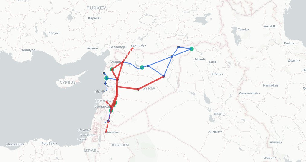
Syria Electricity Transmission Network
Infrastructure Capacity & Connection Analytics
Enhanced Data Version
Total Lines
-
400 kV Backbone
-
Total Installed Capacity
~3,400 MW*
*Select nodes for specifics
Active Interconnections
-
Node Info
Network Components
400 kV (Main Transit)
230 kV (Regional Distribution)
Power Generation Hub
Regional Load Centre
Technical Insight
Backbone Connectivity
The 400 kV circuit facilitates major interconnections with Jordan (Amman-Deir Ali) and Turkey (Birecik-Aleppo). This transit capacity is vital for frequency stability across the Levant.
Fuel Dependency
The thermal plants (Deir Ali, Zayzoun) are gas-dependent. Disruption in gas supply directly affects the generation available to Damascus and Aleppo, leading to load-shedding cycles.
✨ AI Strategic Analysis
The Architecture of Interdependence
To understand the high-voltage infrastructure of the Levant, one must first recognise that electricity networks function as the central nervous system of the modern state. When these systems are compromised, the resulting paralysis extends far beyond industrial output, affecting healthcare delivery, water desalination, and the basic functions of urban governance. In Syria, over a decade of fragmented control and kinetic damage has left a topological baseline that is as much a map of past dependencies as it is a blueprint for future recovery.
The foundation of this current analysis rests upon a comprehensive geospatial dataset retrieved from the World Bank’s Energy Data platform. This raw data, specifically the Syrian Electricity Transmission Network GeoJSON, provides a snapshot of the primary transmission lines (400 kV and 225 kV) and the essential infrastructural nodes that define the grid’s reach. While the operational status of these assets remains fluid due to the prevailing geopolitical climate, the underlying topology provides a fixed point of reference for infrastructure planners and energy strategists (World Bank, 2024).
The visualisation developed herein is designed to bridge the gap between abstract spatial data and actionable intelligence. By mapping generation nodes against transit capacities, the tool allows for a granular examination of the network’s resilience. It moves beyond the static map, employing an interactive dashboard where users can interrogate specific assets and leverage integrated Large Language Models (LLMs) to generate instant strategic reports. This methodology acknowledges that in the modern era, data is only as valuable as the insights it yields.
The 400 kV Backbone: A North-South Corridor
The primary transit corridor of the Syrian grid is defined by its 400 kV backbone. These high-capacity lines form a vertical axis that connects the major load centres of Aleppo, Hama, Homs, and Damascus. From a technical perspective, this corridor is the stabilising force of the national system, designed to move massive quantities of power from distant generation hubs to the industrial and residential heartlands.
Crucially, this 400 kV network is not an island. It was originally engineered to facilitate international interconnections, most notably with Jordan via Amman to the south and Turkey via Birecik to the north. These interconnections position Syria as a vital transit bridge within the regional energy landscape. However, recent assessments indicate that these interconnections are currently non-operational due to conflict-related destruction and prolonged neglect (World Bank, 2025). The restoration of this 400 kV infrastructure is therefore not merely a Syrian priority but a regional economic imperative to re-establish the stability of the Levantine power pool (IEA, 2024).
However, the concentration of these lines along a single north-south axis introduces significant systemic risk. Any disruption to the central corridor can effectively bifurcate the national grid, isolating the southern administrative centres from the northern industrial zones. This vulnerability is exacerbated by high technical losses, estimated at over 6 per cent in the transmission system, compounded by a lack of maintenance and spare parts (World Bank, 2025).
Regional Distribution and the Eastern Frontier
While the 400 kV lines handle the heavy lifting of national transit, the 225 kV sub-transmission network serves as the arterial system for regional distribution. This secondary layer is particularly significant in the eastern provinces of Deir Ez-Zor and Al-Hasakah. These areas are resource-rich, containing the bulk of the country’s oil and gas reserves, yet they remain geographically peripheral to the primary load centres.
The 225 kV circuits connecting the eastern gas fields to the rest of the country are a testament to the challenges of managing a radial network. Unlike a meshed grid, where power can be rerouted through multiple paths, these radial lines are susceptible to single points of failure. If a key substation in the eastern desert is disabled, the entire region can be plunged into darkness. This fragility has profound implications for the energy-water nexus, as the region’s water withdrawals are increasingly dependent on electricity-powered technologies (IEA, 2024).
Furthermore, the topological data reveals a stark contrast between the densely integrated coastal and central regions and the sparsely connected east. This “infrastructure gap” reflects deeper socio-economic divisions. Reconstruction efforts, such as those proposed under the World Bank’s Syria Electricity Emergency Project, will need to address this imbalance, likely through the urgent rehabilitation of damaged high-voltage lines and substations (World Bank, 2025).
Generation Hubs and Strategic Vulnerabilities
No analysis of a transmission network is complete without an examination of the nodes that feed it. In Syria, the generation mix is predominantly thermal, operating well below nameplate capacity due to fuel shortages and maintenance issues. Each of these assets represents a strategic asset and a potential vulnerability.
One of the most critical nodes identified in the visualisation is the Thawra Dam on the Euphrates Lake. With a design capacity of 824 MW, it is a cornerstone of the country’s hydroelectric output. However, its reliance on water levels in the Euphrates makes it vulnerable to both climate-driven droughts and upstream water management decisions. In the thermal sector, facilities like the Deir Ali plant near Damascus represent critical load-bearing assets. As a modern, gas-fired facility, it provides a significant portion of the capital’s baseload power, but its dependency on the gas pipeline infrastructure makes it a high-value target for disruption (World Bank, 2025).
The integrated AI Node Analyst within the dashboard provides a mechanism for real-time risk assessment. By querying a Large Language Model with the specific parameters of a node, such as its fuel type and capacity, the tool generates a strategic analysis of its role in frequency stability and its geopolitical importance. For instance, coastal thermal plants may be assessed as having higher resilience due to their proximity to fuel import routes, whereas inland plants dependent on domestic gas fields are flagged as higher risk.
Data-Driven Insights and the Path to Reconstruction
The ultimate goal of visualising the Syrian electricity network is to provide a clear-eyed view of what currently exists as a prerequisite for what must be built. The “AI Network Report” feature in the dashboard synthesises the entire topological dataset to identify systemic bottlenecks. This macro-level analysis is essential for institutional investors and development agencies who must navigate the substantial environmental and social risks associated with reconstruction.
Decarbonisation represents another significant challenge. The current grid is heavily reliant on fossil fuels, with renewables (excluding large hydro) accounting for only a negligible share of generation. Modernising the Syrian grid will require the integration of solar PV, which could improve resilience in post-conflict areas by bypassing reliance on weakened transmission corridors (IEA, 2024). The data suggests that the existing high-voltage infrastructure could serve as the foundation for this transition, provided that significant investments are made in grid-stabilising technologies and the rehabilitation of the 400 kV interconnectors (World Bank, 2025).
The transition from raw spatial data to strategic insight is a vital step in bridging the information gap that often hampers infrastructure planning in conflict-affected zones. By making this data interactive and accessible, we can move away from speculative assessments and towards a more rigorous, evidence-based approach to energy security.
Conclusion
The Syrian electricity transmission network is a complex, fragile, and essential piece of regional infrastructure. Through the application of geospatial visualisation and artificial intelligence, we have identified the critical importance of the 400 kV north-south corridor, the vulnerability of the radial lines in the east, and the strategic risks associated with key generation hubs. Rebuilding this network will require more than just physical repairs; it will demand a fundamental rethinking of grid architecture in the face of geopolitical and environmental uncertainty. As we look towards a post-conflict future, tools that transform data into actionable strategic intelligence will be the primary instruments of resilience and recovery.
References
International Energy Agency (2024). The Future of Electricity in the Middle East and North Africa. Paris: IEA Publications. Available at: https://www.iea.org/reports/the-future-of-electricity-in-the-middle-east-and-north-africa (Accessed: 6 March 2026).
World Bank (2024). Syria – Electricity Transmission Network (GeoJSON Data). Washington, DC: World Bank Energy Data Platform. Available at: https://energydata.info/dataset/syria-electricity-transmission-network (Accessed: 24 May 2024).
World Bank (2025). Syria Electricity Emergency Project (P511407): Project Appraisal Document. Washington, DC: World Bank Group. Available at: https://documents.worldbank.org/en/publication/documents-reports/documentdetail/099060625055567160/p511407-afa010d5-6fc0-4c0d-859d-79b01a31c3f5 (Accessed: 6 March 2026).